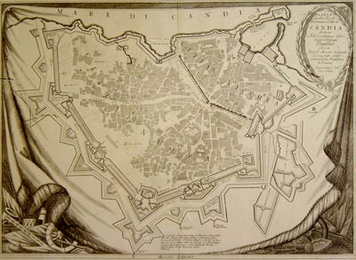
Exhibiton at the Historic Museum of Heraklion , open until April 29
 Crete, queen of the Mediterranean, valuable possession and jewel of the Republic of Venice, rich in history and myths, was also a land beloved of cartographers. At the dawn of the cartographic renaissance in the 15th century, Crete was under Venetian rule. It was the Kingdom of Crete, il Regno di Candia, with the city of Candia as its capital.
Venice needed to defend its valuable possession and protect it from the imminent Ottoman invasion. To this aim, the Serenissima sent engineers to the island to effect studies and measurements which would aid in improving its defences. Francesco Basilicata, one of the greatest engineers of Venice, drew maps presenting the most comprehensive outline of Crete undertaken to that date, together with topographical maps of its fortified positions. In Marco Boschini’s hands, Basilicata’s work became a tool for the fuller cartographical representation of the island. The information the Venetians had at their disposal led to the recording of details and many place-names, as well as representations of contemporary and ancient Crete, as we can see from Coronelli’s large and impressive map.

The exhibition comprises seven sections covering the developments in the cartographical representation of Crete until its fall to the Ottomans. The fall of Candia completed the Ottoman domination of the southeast Mediterranean.
The entrance to the exhibition is free. Opening times: Monday – Saturday: 09.00-14.30, Wednesday afternoons: 18:00-21:00